

March 8, 2014. This was a routine flight was from Kuala Lumpur, Malaysia to Beijing, China. Nothing unusual about the aircraft, the route or the weather. The captain was a respected, veteran pilot, who trained over pilots. Ninety-four minutes after takeoff, MH370 disappeared from radar and communications as it entered Vietnamese airspace.

Because it was leaving one airspace and entering another, the aircraft would not be initially missed. This would be the beginning of a series of aviation failures, that in part doomed the aircraft and those aboard. When MH370’s disappearance was noted, authorities focused on that last air traffic control radar/transponder location on the route. However, Malaysian military data would reveal the airplane turned sharply after the transponder was shut off and the satellite communications system was also interrupted. Military tracking of MH370 failed to get any response; no fighter intercepts were launched to investigate, it was thought to be just a commercial airplane that was in contact with air traffic controllers. Only it was not. Whomever was piloting the airplane carefully flew between several countries’ airspace where it did not arouse suspicion, to do so helped it remain “invisible.” Each airspace control center thought the other was in contact with the aircraft. No one was in contact with the aircraft.

Unknown to most, MH370 was being traced on pings or “handshakes” from the airplane to a satellite. The ping data in this case was received by a private company, Inmarsat, as part of the normal transmission of engine performance data. Later, Inmarsat (a British company) turned the data over to British authorities. This engine tracking system was unknown by many in the aviation industry, and illustrates how uncoordinated the various tracking systems are, in addition to the lack of response to a missing aircraft which wondered into military airspace without investigation. MH370 revealed a porous system of tracking and response.
Military radar and Inmarsat data would later reveal that MH370 flew seven hours after the transponder and communications (the satellite system communicating engine data would suddenly switch back on) were switched off, mostly in a southern direction, although data shows MH370 executing turns and a 20-minute holding pattern before resuming the southern direction. The question is: Who was flying the plane, because those actions are not consistent with a ghost flight.
Mysteries and unanswered questions. Outside of Amelia Earhart, MH370 would be the greatest aviation mystery in history.

MH370 Facts (compiled from various sources):
Flight 370 was operated with a Boeing 777-2H6ER, serial number 28420. It had accumulated 53,471.6 hours and 7,526 cycles (takeoffs and landings) in service and had not previously been involved in any major incidents.
It was one of two daily flights operated by Malaysia Airlines from its hub at Kuala Lumpur International Airport (KLIA) to Beijing Capital International Airport—scheduled to depart at 00:35 local time (MYT; UTC+08:00) and arrive at 06:30 local time (CST; UTC+08:00).
The planned flight duration was 5 hours and 34 minutes, which would consume an estimated 37,200 kg (82,000 lb) of jet fuel. The aircraft carried 49,100 kilograms (108,200 lb) of fuel, including reserves, allowing an endurance of 7 hours and 31 minutes. The extra fuel was enough to divert to alternate airports—Jinan Yaoqiang International Airport and Hangzhou Xiaoshan International Airport—which would require 4,800 kg (10,600 lb) or 10,700 kg (23,600 lb), respectively, to reach from Beijing.
On board were two pilots, 10 cabin crew, 227 passengers, and 14,296 kg (31,517 lb) of cargo.
The pilot in command was 53-year-old Captain Zaharie Ahmad Shah from Penang. He joined Malaysia Airlines as a cadet pilot in 1981. Zaharie had a total of 18,365 hours of flying experience. The co-pilot was 27-year-old First Officer Fariq Abdul Hamid. He joined Malaysia Airlines as a cadet pilot in 2007. Fariq had accumulated 2,763 hours of flying experience.
Of the 227 passengers, 153 were Chinese citizens, 38 passengers were Malaysian. The remaining passengers were from 12 different countries.
The Disappearance Timeline (source, Wikipedia):
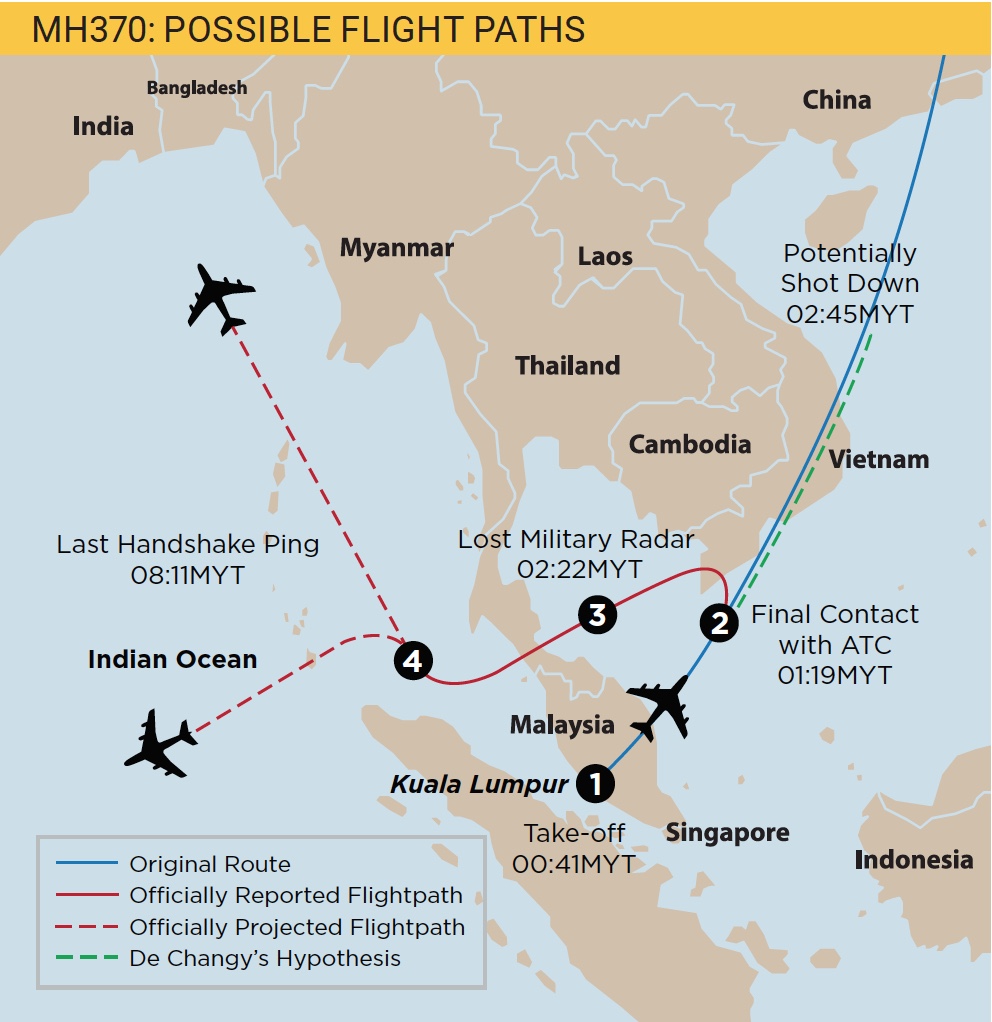
March 8, 2014, at 00:42 MYT, Flight 370 took off from runway 32R.
At 01:01, Flight 370’s crew reported to Lumpur Radar that they had reached flight level 350, which they confirmed again at 01:08.
The aircraft’s final transmission was an automated position report, sent using the Aircraft Communications Addressing and Reporting System (ACARS) protocol at 01:06 MYT.
The last verbal signal to air traffic control occurred at 01:19:30, when Captain Zaharie acknowledged a transition from Lumpur Radar to Ho Chi Minh ACC.

The crew was expected to signal ATC in Ho Chi Minh City as the aircraft passed into Vietnamese airspace, The captain of another aircraft attempted to contact the crew of Flight 370 shortly after 01:30, using the international air distress frequency, to relay Vietnamese air traffic control’s request for the crew to contact them; the captain said he was able to establish communication, but heard only “mumbling” and static.
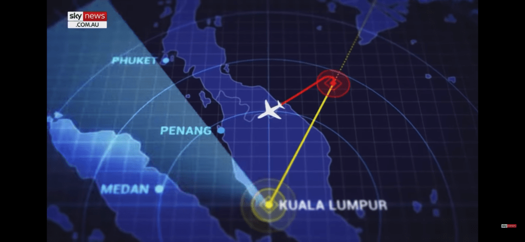
At 01:20:31 MYT, Flight 370 was observed on radar at the Kuala Lumpur ACC as it passed the navigational waypoint IGARI (6°56′12″N 103°35′6″E) in the Gulf of Thailand; five seconds later, the Mode-S symbol disappeared from radar screens. At 01:21:13, Flight 370 disappeared from the radar screen at Kuala Lumpur ACC and was lost at about the same time on radar at Ho Chi Minh ACC, which reported that the aircraft was at the nearby waypoint BITOD. Air traffic control uses secondary radar, which relies on a signal emitted by a transponder on each aircraft; therefore, the ADS-B transponder was no longer functioning on Flight 370 after 01:21.

Indonesia, Thailand and Vietnam also detected Flight 370 on radar before the transponder stopped working.
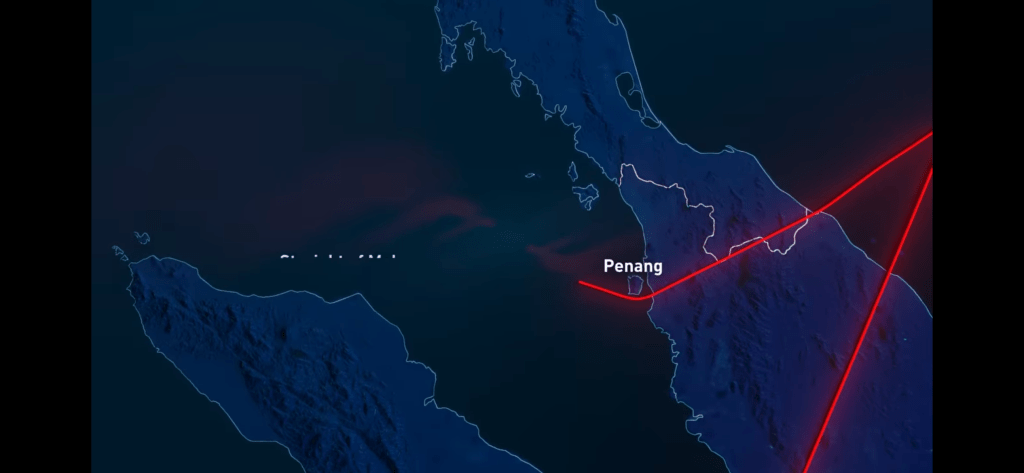
At the time that the transponder stopped functioning, military radar showed Flight 370 turning right, but then beginning a left turn to a southwesterly direction. From 01:30:35 until 01:35, military radar showed Flight 370 at 35,700 ft (10,900 m) on a 231° magnetic heading, with a ground speed of 496 knots (919 km/h; 571 mph). Flight 370 continued across the Malay Peninsula, At 01:52, Flight 370 was detected passing just south of the island of Penang (making a sharp turn). From there, the aircraft flew across the Strait of Malacca. The last known radar detection, from a point near the limits of Malaysian military radar, was at 02:22, 10 nmi (19 km; 12 mi) after passing waypoint MEKAR.

At 01:38 MYT, Ho Chi Minh Area Control Centre (ACC) contacted Kuala Lumpur Area Control Centre to query the whereabouts of Flight 370 and informed Kuala Lumpur that ACC had not established verbal communication with Flight 370.

At 02:25 MYT, the aircraft’s satellite communication system sent a “log-on request” message—the first message since the ACARS transmission at 01:07—which was relayed by satellite to a ground station, both operated by satellite telecommunications company Inmarsat. After logging on to the network, the satellite data unit aboard the aircraft responded to hourly status requests from Inmarsat and two ground-to-aircraft telephone calls, at 02:39 and 07:13, which were unanswered by the cockpit.
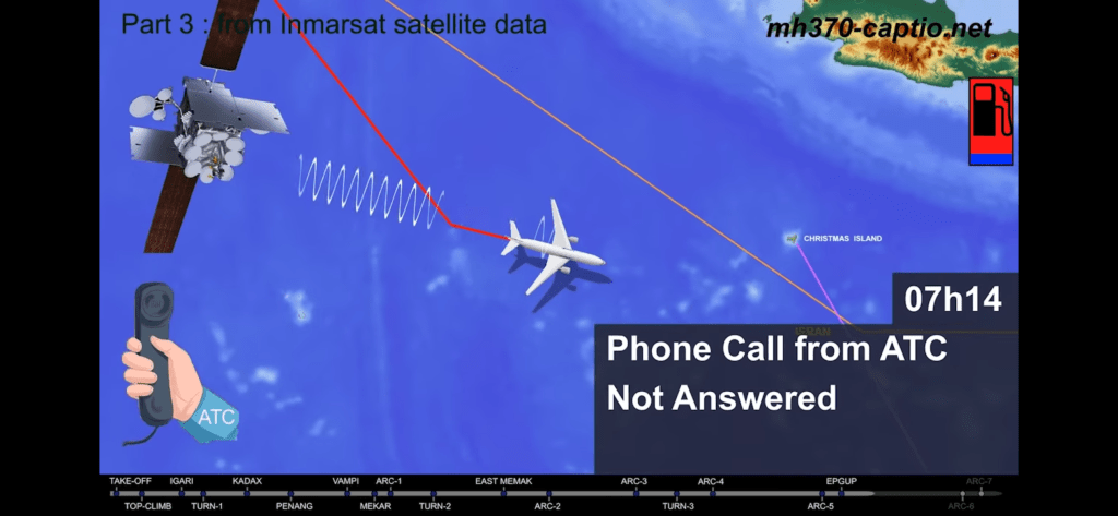
The final status request and aircraft acknowledgement occurred at 08:10, about 1 hour and 40 minutes after it was scheduled to arrive in Beijing. The aircraft sent a log-on request at 08:19:29, which was followed, after a response from the ground station, by a “log-on acknowledgement” message at 08:19:37. The log-on acknowledgement is the last piece of data available from Flight 370.


The watch supervisor at Kuala Lumpur ACC activated the Kuala Lumpur Aeronautical Rescue Coordination Centre (ARCC) at 05:30, more than four hours after communication was lost with Flight 370.
Malaysia Airlines issued a media statement at 07:24 MYT, one hour after the scheduled arrival time of the flight at Beijing. The Malaysian government has been heavily criticized for many things, from failing to investigate a wayward MH370, to not disclosing the new search area, to withholding evidence, and poor treatment of victim families.
The Search:
The search for MH370 has been the most expensive and exhausting, multinational search in history. Malaysia quickly assembled a Joint Investigation Team (JIT), consisting of specialists from Malaysia, China, the United Kingdom, the United States, and France.

As a Malaysian aircraft, departing from Malaysia, the responsibility fell to the Malaysian government. Search operations and official statements would be overseen by Malaysia, although later search operations of the Southern Indian Ocean would by under the direction of the Australian Transport Safety Board. Malaysian officials would be heavily criticized by many for their lack of transparency and stonewalling in response to the disappearance and handling of the search.
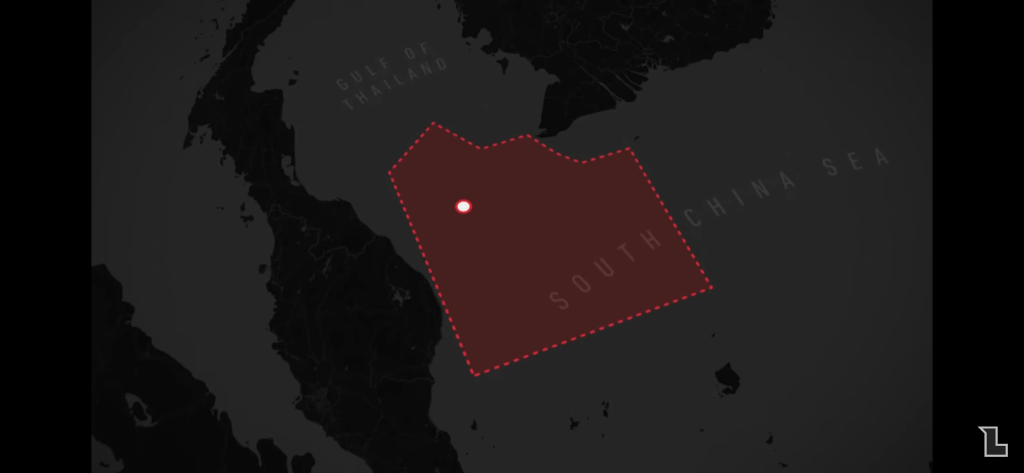
The initial search was in the South China Sea, between Malaysia and Vietnam, naturally at the last known area for MH370. Thirty-four planes and forty ships converged on the area. There were many reports of debris, oil slicks and theories – though none were substantiated.
CNN correspondent Richard Quest, who covered aviation matters and Asia, writes that Malaysia quietly began searching the west coast on Malaysia and almost three days after the disappearance offered the possibility that MH370 “might have turned back.” The search was shifted to the Southern Indian Ocean as new data of MH370’s turn back became more clear. Precious time was lost as the search effort focused on the flight plan, not what the military data revealed.
Surface operations included 22 military aircraft and 19 ships from eight countries (Australia, New Zealand, China, Japan, Malaysia, South Korea, United Kingdom and the United States). The 52 days of the surface search involved aircraft and surface vessels and covered an area of 4.2 million square kilometres.
“The underwater search started with a bathymetry survey which continued to be updated throughout the underwater search and mapped a total of 710,000 square kilometres of Indian Ocean seafloor, the largest ever single hydrographic survey. The high resolution sonar search covered an area in excess of 120,000 square kilometres, reaching depths of 6,000 metres, also the largest ever search or survey of its kind.” – Australian Department of Infrastructure, Transport, Regional Development, Communications and the Arts, on behalf of the Joint Agency Coordination Centre

The Search Timeline (sources: Wikipedia, LiveScience articles by Tom Sharp, and the Australian government)

March 8. A search-and-rescue effort is initiated in the South China Sea and Gulf of Thailand around the location at which Flight 370 lost contact with air traffic control.
March 10. The Royal Malaysian Air Force confirms Flight 370 made a “turn back”.
March 14. Inmarsat publicly acknowledges they recorded transmissions from the aircraft for several hours after it disappeared from air traffic control over the South China Sea.
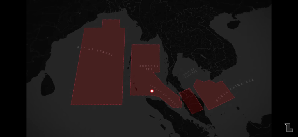
March 15. The final communication was made along one of two arcs; a “northern corridor” stretching from northern Thailand to Kazakhstan and a “southern corridor” from Indonesia into the southern Indian Ocean. Prime Minister Najib says the search in the South China Sea will be ended and the deployment of assets re-assessed.
March 18. Australia conducts its first aerial search of the southern Indian Ocean.
Oceanographers indicated in the time between the disappearance and the first eyes on the new search area was 10 days. Two cyclones in a remote area with normally rough waves and high winds could have scattered or waterlogged (sank) significant debris. The delay was yet another lost opportunity and sacrificed valuable search time.
March 24. Malaysia’s Prime Minister Najib announces at a press conference at 22:00 local time (Malaysia) that Flight 370 is presumed to have gone down in the southern Indian Ocean with no survivors.

March 28. The search shifts to a new 319,000-square-kilometre (123,000 sq mi) area around 1,100 kilometres (680 mi) north-east of the previous search area.
April 28. Surface search ended. The surface search in Southeast Asia and the Indian Ocean lasted 52 days, during 41 of which Australia coordinated the search. Over 4,500,000 km2 (1,700,000 sq mi) of ocean surface was searched. In the Southern Indian Ocean, 29 aircraft from seven countries conducted 334 search flights; 14 ships from several countries were also involved.
May 28. The seafloor sonar survey is completed. After 30 deployments of the Bluefin-21 to depths of 3,000–5,000 m (9,800–16,400 ft), which scanned 860 km2 (330 sq mi) of seabed, no objects associated with Flight 370 were found. The following day, after analysis of data from the last mission, the ATSB announces the search in the vicinity of the acoustic detections is complete and the area can be discounted as the final location of Flight 370.
August 6. Australia awards Fugro a A$50 million (US$46,6 million) contract to conduct the underwater search.
October 2014 – June 2015. The underwater search commences on 6 October. The search involves four vessels: the GO Phoenix (October 6–June 20), Fugro Discovery (joined search October 23), Fugro Equator (joined search 15 January), and Fugro Supporter (January 29–early May). During the bathymetyric survey, 208,000 km2 (80,000 sq mi) of seafloor was charted.
July 2015 – January 2018. July, 29, 2015, a piece of marine debris is found on Réunion—an island in the western Indian Ocean—that resembled an aircraft component. The object is confirmed to be a flaperon from a Boeing 777.

March 8, 2015. Exactly one year after the disappearance of Flight 370, the Malaysian Ministry of Transport issued an interim report titled “Factual Information: Safety Information for MH370”, which focused on providing factual information about the missing airplane, rather than the analysis of possible causes of the disappearance.
Feb. 27, 2016. Two more Boeing 777 debris objects are discovered on a beach in Mozambique. An analysis completed on March 24 concluded that “the debris is almost certainly from MH370,”
July 30, 2016. A large wing part found on a Tanzanian island “highly likely” came from the missing aircraft, according to Australia’s transport minister.
October 7, 2016. A fragment of a wing discovered in Mauritius in May is confirmed as coming from the missing plane.
The underwater search commenced on May 5, 2014 and concluded on January 17, 2017, pending the discovery of additional credible information.
As of April 30, 2017, a number of pieces of debris have been located on the east coast of Africa, Mozambique and La Reunion Island, with three items confirmed as being from MH370 and seven pieces confirmed as almost certainly from the aircraft.


Disappearance Theories (various, including Netflix docu-series):
These are not my theories, just some of the more notable possibilities.
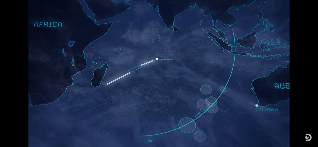
According to various sources, two American AWAC planes tracked MH370. Theories suggest MH370 was forced to land at Diego Garcia to prevent the plane from crashing and destroying a strategic military installation at Diego Garcia. So, what did the Americans do with the airplane and passengers? Even if no action was taken against MH370, what does the AWAC data show?
Lithium batteries in the cargo hold may have caught fire, destroyed the electronics, filled the aircraft with toxic fumes, and then disabled the plane. Another theory is the Chinese were importing sensitive technology in the cargo hold labeled as lithium batteries. The AWACs could have jammed MH370’s communications to make it disappear from the electronic screen. The airplane was intercepted and downed when the pilot refused to divert under orders of the U.S. military. Someone analyzing high image photography of the area in Vietnamese airspace saw what she believed to be debris consistent with an airplane similar to MH370. The cargo was checked when it was loaded but not X-rayed as is the protocol. The cargo also included a shipment of fruit that was strangely not in season.
Was the airplane, instead of going south, diverted north by Russian agents who took control of the plane by taking over the flight control system and turning off the transponder. They could have sent phantom data to the satellite tracker, while heading toward Kazakhstan, a Russian client state. Months later, another Malaysian 777 airliner was shot down in Ukraine by Russian separatists under the command of Russian intelligence. Coincidence?

Journalist Florence de Changy, who wrote The Disappearing Act, about MH370, says the airplane went down in the South China Sea, not in the South Indian Ocean. She points a finger at the U.S. for some nefarious involvement. In her research, she refuted the theory that MH370 turned back and flew south for seven hours. I have acquired a copy of her book and will summarize it and other books at a later time.
Sixteen months after MH370’s disappearance, a wing piece was found on a beach in Indian Ocean. Experts concluded the piece was part of MH370. Of course, there were skeptics. The airplane part lacked the I.D. plate, which naturally, raised doubt in some circles.

Another piece of debris was found on the eastern coast of Mozambique. Blaine Gibson actively searched for and found multiple pieces. Naturally, Gibson comes under suspicion for finding “planted” airplane debris, possibly by Russia. Journalists looked deeper at adventurer Gibson and find a business connection with Russia.
What about the two stolen Italian passports used by two Iranians onboard, but not on the correct passenger manifest? Investigators determined they were asylum seekers, not terrorists. Malaysia says these passports were not checked with the online database for missing passports. There were also four ticket-holders who did not board MH370. No baggage was reported removed from the airplane and their seats were given to four travelers on standby. Malaysian Airways was heavily criticized for not being able to produce an accurate passenger manifest.

The airplane’s satellite communication system was still operational, meaning members of the crew or passengers could have sent text messages or other communications while the airplane was flying “off the radar.” No one sent any such communications. Were they all incapacitated or dead? The only active phone was the first officer’s phone, which received a call that was not answered.
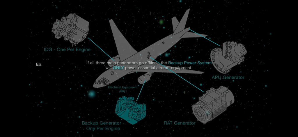
The Boeing 777 has multiple sources of power. Each engine generates power for the aircraft’s various systems. In addition, there is another generator in the tail section. Should those fail, there is a wind turbine that is deployed that would power only critical equipment to fly the aircraft. These redundant generators are there for catastrophic failure protection.
So, Where’s the Airplane?
Despite the years of searching and hundreds of millions of dollars spent, the exact location is still a mystery. Journalists, experts, theorists, governments and families of passengers do not agree on what happened to MH370.
Outside of the formal investigation, a numbers of pilots, scientists, journalists and other experts joined several groups to investigate the disappearance, one of which, named the Independent Group. Another group, CAPTIO (Constraints on Alternative Piloted Trajectories in the Indian Ocean), is a team of pilots, aeronautic researchers, electronics engineers, aerospace simulation and terrorism.

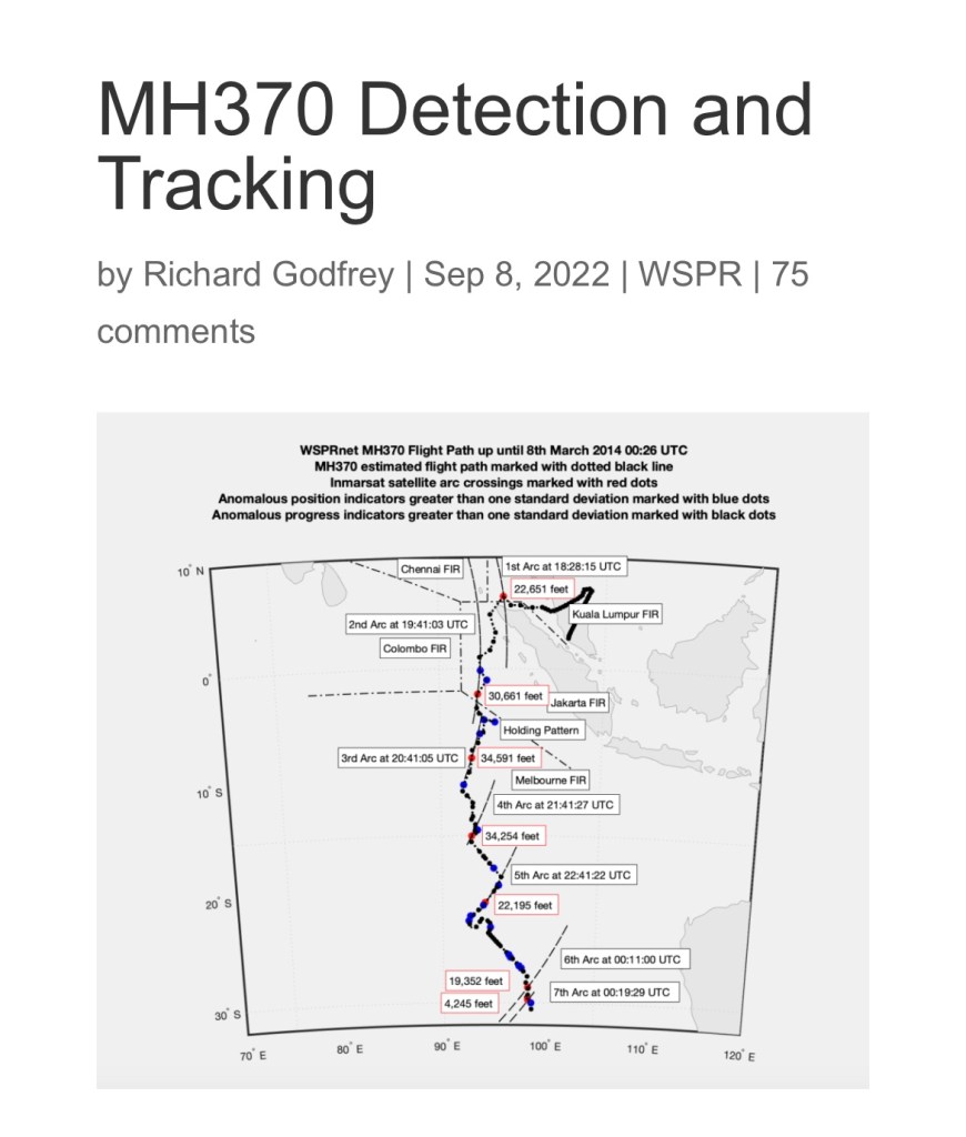
The Inmarsat data made several handshakes with MH370. After the power was restored to MH370 (it had been turned of when the transponder was switched off), the airplane and the satellite made a series of hourly handshakes, simply to let the satellite know that the airplane was still there. Each of these handshakes produced an “arc” of where MH370 might be given the distance and time of contact. The last handshake established the 7th arc, thought to define the area where the plane would go down when fuel was exhausted. The arc is not an exact location and the possible area is vast.

Looking at the debris, particularly the flaparon, it suggests a water landing given the type of damage (trailing edge erosion), rather than MH370 falling from the sky in a rapid dive. Based on past water crashes, airliners that fall from a high altitude with great speed break into millions of pieces. Lower speed, water landings decrease the potential breakage. Given the lack of debris recovered and the flaperon condition, a pilot-guided water landing is what many experts and theorists believe.

Most of the suspicion has centered Captain Zaharie. He had a flight simulator in his basement, which is not that unusual for flight instructors. The FBI reviewed the simulator’s hard drive and found he had flown simulations close to where investigators suspect the airplane’s final location. This was rejected by some who felt this was too coincidental. Zaharie was respected and did not arouse the normal suspicions where a pilot is suspected in a crash. However, Zaharie was politically active, and one the political persons he admired was found guilty of a crime the on March 7, the day before the flight. Interesting, after MH370 was thought to turn back, it made a sharp turn around the island of Penang, Zaharie’s boyhood location, and that the wing ofMH370 appeared to dip, as a salute. Aviation experts agree that such a turn had to have been a piloted action, not autopilot.


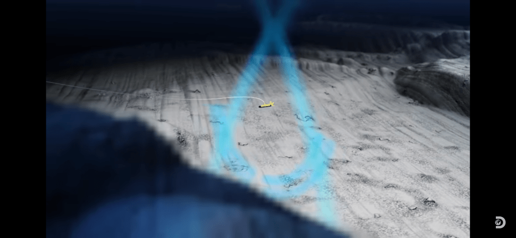
As debris was found years later, the debris has caused further division. Is the debris legitimate or placed there? Not all of the pieces could be confirmed as MH370, but some are believed to belong to MH370. Examination of the flaperon shows erosion evidence that it was deployed when striking the ocean, meaning a controlled landing rather than a high speed crash. That’s significant, a high speed crash would suggest the plane was not actively piloted and it ran out of fuel, which would have disintegrated the aircraft. A landing suggests the plane would be in large pieces. Unfortunately, the ocean floor is rugged with ridges and canyons at a depth of 4000 feet.

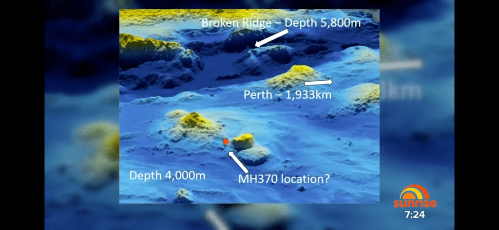
Then, an interesting development. A ham radio operator came forward with data that he is convinced is MH370’s final location, basing it on the disturbance of radio waves the airplane made as it flew through them. By looking at the anomalies, he claims the flight path can be tracked to the end. Richard Godfrey, an information technology consultant, used the radio wave anomalies (WSPR) to come up with the same path the satellite pinging data did; except Godfrey presents more precise data. According to Godfrey, MH370 was the only airplane in the South Indian Ocean at the time, so it was easy to track.

The Australian government searched 120,000 square miles of ocean, but Godfrey can narrow the area to 300 square miles for another search effort. Some of the 300 square miles has been searched, but due to the rugged underwater terrain, even experts admit something could have been missed. The Australian government is reviewing their data, so a new search is possible. Godfrey told 60 Minutes Australia that he gave the Malaysian government his data, but there has been no further word.
In addition, Professors Charitha Pattiaratchi and Ems Wijeratne published their drift analysis in an article titled “Ocean currents suggest where we should be looking for missing flight MH370. Pattiaratchi and Wijeratne, of the University of Western Australia, are experts on ocean currents, provide a detailed drift analysis, which predicted where debris would turn up. They used several locations near the 7th arc as possible points of origin. One of these points is the same as the WSPR location.


Kazakistan? See above.
The Inmarsat data is fake.
Aliens.
Hijacking.
An explosive device.
Shot down to prevent the cargo from ending up in China.
—
Somewhere underwater, whether it went down between Malaysia and Vietnam, the southern Indian Ocean or some other watery location, it’s likely thousands of feet below the surface, in many of pieces. Will the mystery ever be solved?
Part II of my look at MH370 will focus on the books written about the mystery. In the meantime, there are tens of programs on YouTube about MH370, in addition to a three-part series on Netflix.


Leave a comment